
Tools & Technology: Lidar
Lidar (Light Detection and Ranging)
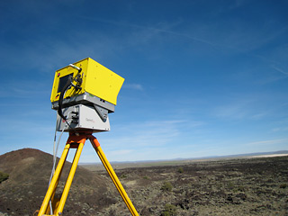
We'll be using a lidar on Mt Morning to produce highly detailed, 3-dimensional maps of rock faces, lava flows, and individual boulders. As geologist Adam Soule puts it, using a lidar is a little bit like taking a picture of your house with a digital camera, except with the lidar you can see how far the doorknob sticks out from the front door, and you can look inside the gaps between the shingles on the roof. Once the image is stored on a computer, software lets you rotate the image in any direction to get a better look at interesting features.
A lidar looks a little like a milk crate standing on a tripod. Inside the crate is a laser that shines pulses of light at its target, which can be anywhere from arm's length to more than a hundred meters away. An extremely accurate stopwatch in the instrument times how long it takes each light pulse to bounce back to the instrument. That tells the computer the shape of the surface, down to a centimeter or less.
The lidar will help the expedition's geologists make very detailed measurements of the way rocks age and break apart in the dry cold of the Antarctic. They'll also be able to compare their maps of the lava flows with ones they make on future visits, to track how quickly the rock has changed.
[ back ]